Originalmente Colocado por Vanquish
Ver Post
-
Longe disso, infelizmente... -
Quando as galinhas tiverem dentesOriginalmente Colocado por bg2 Ver Post . Existiu isso na época dos incendios e foi p tapar os olhos
Comentário
-
-
Se fôssemos os espanhóis já tínhamos feito um canal de alto a baixo, pra drenar pra o Alentejo o excesso de águas no Norte. Transvazes. Aqui, nem sabemos que isso existe.Comentário
-
-
Chove forte (mais uma vez) na Região Metropolitana de Lisboa....Comentário
-
Bom, desta vez avisaram devidamente. 😉Comentário
-
Comentário
-
Vai estar forte cá por cima, o Windy prevê que comece ao início da manhã e se prolongue até á tardeComentário
-
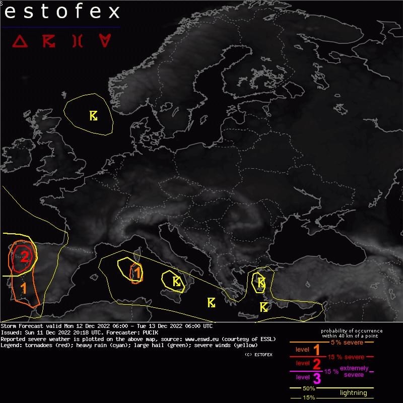
Norte e Centro
⚠️VENTOS SEVEROS, POSSIBILIDADE DE TORNADOS, TROVOADAS E PRECIPITAÇÃO EXCESSIVA.
▶️A level 2 was issued across NW Spain and N Portugal mainly for severe wind gusts, tornadoes and heavy rainfall.
▶️... W Iberia ...
The highest likelihood of severe weather is forecast over NW Spain and N Portugal. In the early morning hours, a large stratiform rain shield will cross the region, associated with a warm front, followed by an advection of moist airmass inland. Skinny CAPE profiles with MLCAPE values up to 500 J/kg are simulated along the coastline, decreasing inland. Very strong low-level shear is forecast as 1 km AGL flow will vary between 20 and 30 m/s. Any convective storm may pose a risk of severe wind gusts. As the 0-1 km shear will exceed 15 m/s and LCLs will be low, the tornado threat will be enhanced as well. The degree of tornado threat will depend on how much the CAPE can overlap with more strongly curved hodographs that will be available especially early into the forecast period. Some models show a combination of SRH > 200 m2/s2 in the 0-1 km layer and non-zero surface-based CAPE. The largest threat of tornadoes and severe wind gusts will exist between 06 and 12 UTC. Further storms will be possible during the whole day, suggesting a heavy rainfall threat where multiple storms move over the sample place.
Over S Portugal and SW Spain, the severe weather risk will be lower, but the same threats can be expected.Comentário
-
Esperam que as lojas fechem e agora é que avisam....
Onde vou a esta hora comprar uma canoa?

Comentário
-
-
Aqui no Alentejo IPMA continua a exagerar mas previsões. Muito melhor tempo que o previsto.Comentário
-
Tempo espetacular aqui Viana! Para os caracóis!
Aproveito a publicidade do antiembaciante e do repelente de água do Lidl, funcionam bem.
Lado esquerdo com os produtos, lado direito sem tratamento.
Editado pela última vez por Tux; 12 December 2022, 07:54.Comentário
-
Usam alguma app que dê notificações de chuva fiáveis? Obrigado.Comentário
-
-
Havia o RainX que era excelente. N sei se ainda existe.Comentário
-
Basta limpar os vidros com Ajax (passe a publicidade) que isso acontece.Comentário
-
Então, a seca já lá vai??Comentário
-
Que belo dia de chuva aqui pelo norte, talvez seja altura de o governo pensar em criar transvases e aproveitar grande parte da água desperdiçada para o Alentejo e AlgarveComentário
-
Mesma hora e mesmo dia ou montagem?Originalmente Colocado por eblase Ver Post
O radar do ipma não teria o porquê de mostrar reflexos errados...Comentário
-
Acho que a questão é mais... São ambos imagens de radar ou a do IPMA é radar e a da direita uma previsão?
Edd
Comentário
-
Depois de 4 anos com precipitação abaixo do normal ainda é preciso chover muito para repor os níveis de água nas barragens e aquíferos. Lá porque houve inundações em Lisboa não quer dizer que a seca já tenha passado.Originalmente Colocado por Erva Ver Post
Ainda há muitas barragens com níveis baixos de armazenamento: https://barragens.pt/Comentário
-
Pelos arrabaldes a Oeste de Lisboa, desde as 17h 30m, sensivelmente, que chove sem parar, mas desde há 10 minutos, que chove copiosamente.Comentário
-
Tal como já alguém referiu num fórum especializado, se o radar do The Weather Channel estiver correto, a noite de 4ª feira na AML vai parecer uma criança por comparação com esta. Esperemos que não...
Captura de ecrã 2022-12-13 004214.jpgComentário
-
Espero que o pessoal de Lisboa esteja bem, parece que a noite não foi nada fácilComentário
-
Ironia das ironias...
Nunca cheguei tão depressa a Lisboa como hoje...
Comentário
-
nao sei como foi a noite, so sei que nao ha comboios e metro porque está tudo alagado de água..que horror..muitas estradas fechadas tambem..espero que amanha isto ja nao esteja assim mas dizem que ainda vai piorar durante a manha de hoje
ja vi algumas imagens da estacao de entrecampos e fiquei parvaComentário


Comentário